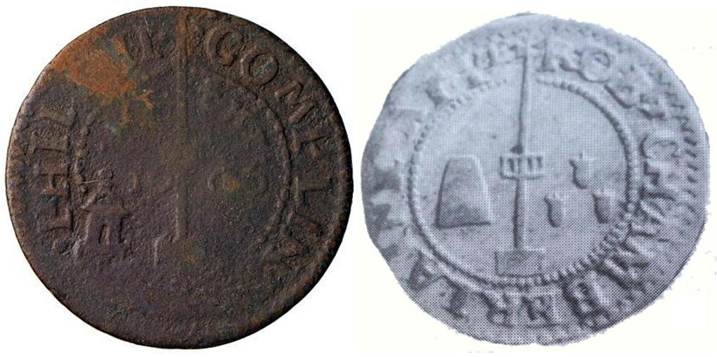
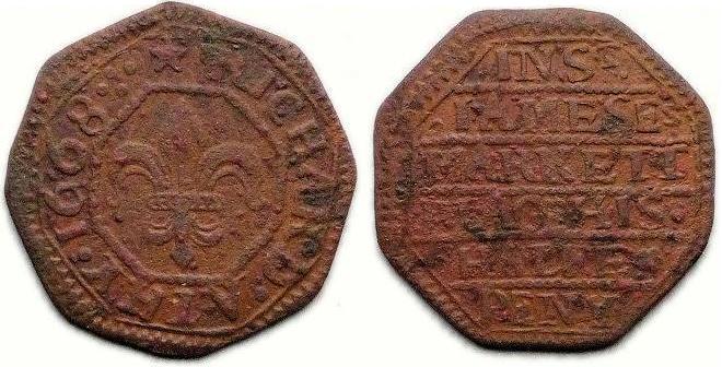
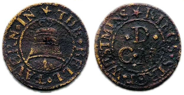
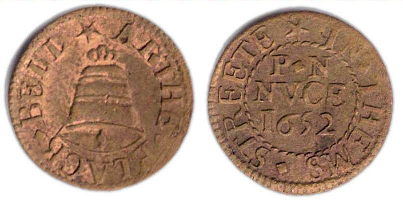
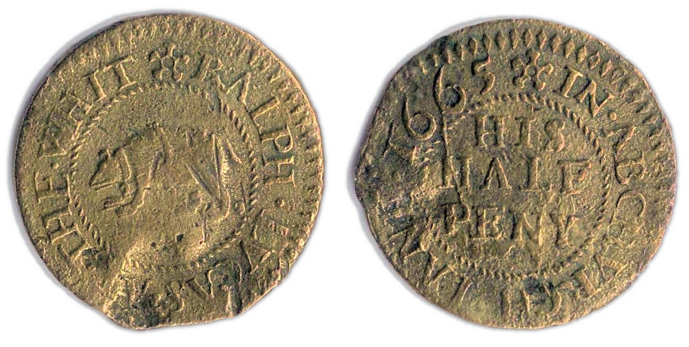
The mid-17th century copper farthing tokens illustrated below are of similar weight (0.98 grams and 0.95 gams respectively) and size (15.4 mm and 15.7 mm respectively) and were both issued by the same person, namely John Kent, a vintner and citizen of London. The designs of the two tokens are described further below.
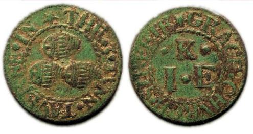
A farthing token issued in the name of the Three Tuns tavern in Gracechurch Street, London
Obverse: (mullet) THE. 3. TVNN. TAVERNE. IN , around a twisted wire circle, within the depiction of three barrels in a triangular stacked arrangement.
Reverse: (mullet) GRACE.CHVRCH.STREETE, around a twisted wire circle, within a triad of initials comprising I | .K. | .E
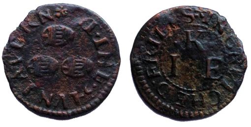
A farthing token issued in the name of the Three Tuns tavern in Crutched Friars, London.
Obverse: (cinquefoil) AT . THE . 3 . TVN . TAVERN , around the depiction of three barrels in a triangular stacked arrangement.
Reverse: (cinquefoil) IN . CRVTCHED . FRIERS , around a twisted wire circle, within a triad of initials comprising I | .K. | .E
The two separate business addresses given on the reverse side of each of these tokens (.i.e. Gracechurch Street in the Candlewick Ward of the city and Crutched Friars in the Tower Ward of the city) clearly indicates that they were issued from two different taverns but with a shared common name (i.e. the Three Tuns). The Three Tuns was a fairly common tavern sign in 17th century London. It is derived from the ancient coat of arms of the Vintners Company of London which, like the token, depicts three wine barrels lying on their sides and arranged in a triangular pattern.
The common triad of initials on the reverse of the above tokens are those of their respective issuers which in this case were John (i.e. where “I” represents “J” in the Latin alphabet) and his wife Elizabeth Kent.
Visually the two above tokens look very similar. The difference in their surface colouring is indicative of the chemical conditions that each has been exposed to since being lost in the mid-17th century. The dark green patina of the first is telling of it being buried for a considerable period in chemically rich soil. The dark brown toning of the second is typical of it being recovered from waterlogged and low oxygen content conditions and is typical of most such tokens recovered from the River Thames foreshore.
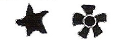
Examples of Legend dividers on 17th Century British Tradesman’s tokens – A mullet (left) and a cinquefoil (right)
Stylistically the first of the two tokens appears to be the older of the two. The use of the “mullet” ornament as a divider in both the obverse and reverse legends is typical of tokens dating from 1648/9 to c.1662. The alternative use of a “cinquefoil” ornament as a legend divider in the second token is indicative of a later issuing date, typically c.1662 to 1668. By the time of this second issuing period farthing tokens were being struck in far fewer numbers in comparison to half penny denomination trade tokens.
In Search of the History of John Kent & his Family
John Kent, the token issuer, was the son of John Kent a yeoman of Standon in rural Hertfordshire. In December 1631 John was sent by his father to London to be apprenticed to George Gopsell a citizen and vintner of the city (1). Like other boys entering trade apprenticeships during this period he would typically have been around fourteen years of age (i.e. suggesting his year of birth as 1617). He would have been expected to work and learn his trade under his new master for approximately seven years before receiving his freedom and becoming a member of the Worshipful Company of Vintners. There after (i.e. c.1638) he would have been free to practice his trade independently.
It is not known where in London John Kent first set up his own business but within three years after completing his apprenticeship he appears to have already established himself and felt sufficiently confident to take on an apprentice of his own on 1st June 1641 (1). This was to be the first of many apprentices he took on over his long career (Note 1). By 1643 John was obviously financially secure and settled enough to get married. His bride was Elizabeth Winch, the daughter of a grocer and church warden originally from the parish of St. Mildred, Poultry in the Cheap Ward of the city (2). The couple married in the parish church of St. John, Hackney on 23rd December 1643. Two years later there is parish register evidence that they were living in the parish of All Hallows, Lombard Street in the Candlewick Ward of the city. John was to retain strong ties to All Hallows parish church for the rest of his life.
Within a couple of years of the marriage of John and Elizabeth the parish registers of All Hallows, Lombard Street record the christenings of their first two children, Mercy and Elizabeth Kent.
12th October 1645 – Merse the daughter of John and Elizabeth Kent was baptised.
4th November 1649 – Elizabeth the daughter of John Kente was baptised.
In 1654 the church warden’s accounts of St. Benet, Gracechurch record his tenancy in Gracechurch Street from that year until the Great Fire in 1666 (3). It has been suggested that his first business in the street was based at the Cock Tavern (4). However, by the start of 1656 he and his family were most definitely in the Three Tuns Tavern as the following family burial entries from the parish registers of All Hallows, Lombard Street confirm;
Samuell Kent – Samuell the son of John Kent, vintner, & of Elizabeth his wife was buried in the South chapel on the south side under the pew marked 9 upon the 13th day of January Anno. 1655
Francis Kent – The daughter of John Kent vintner at the 3 tuns in Gracechurch Street and Elisabeth his wife was buried in the South Chapel on ye south side underneath the pews marked 9 and 10 upon the 10th day of February in the year aforesaid (i.e. 1655/6).
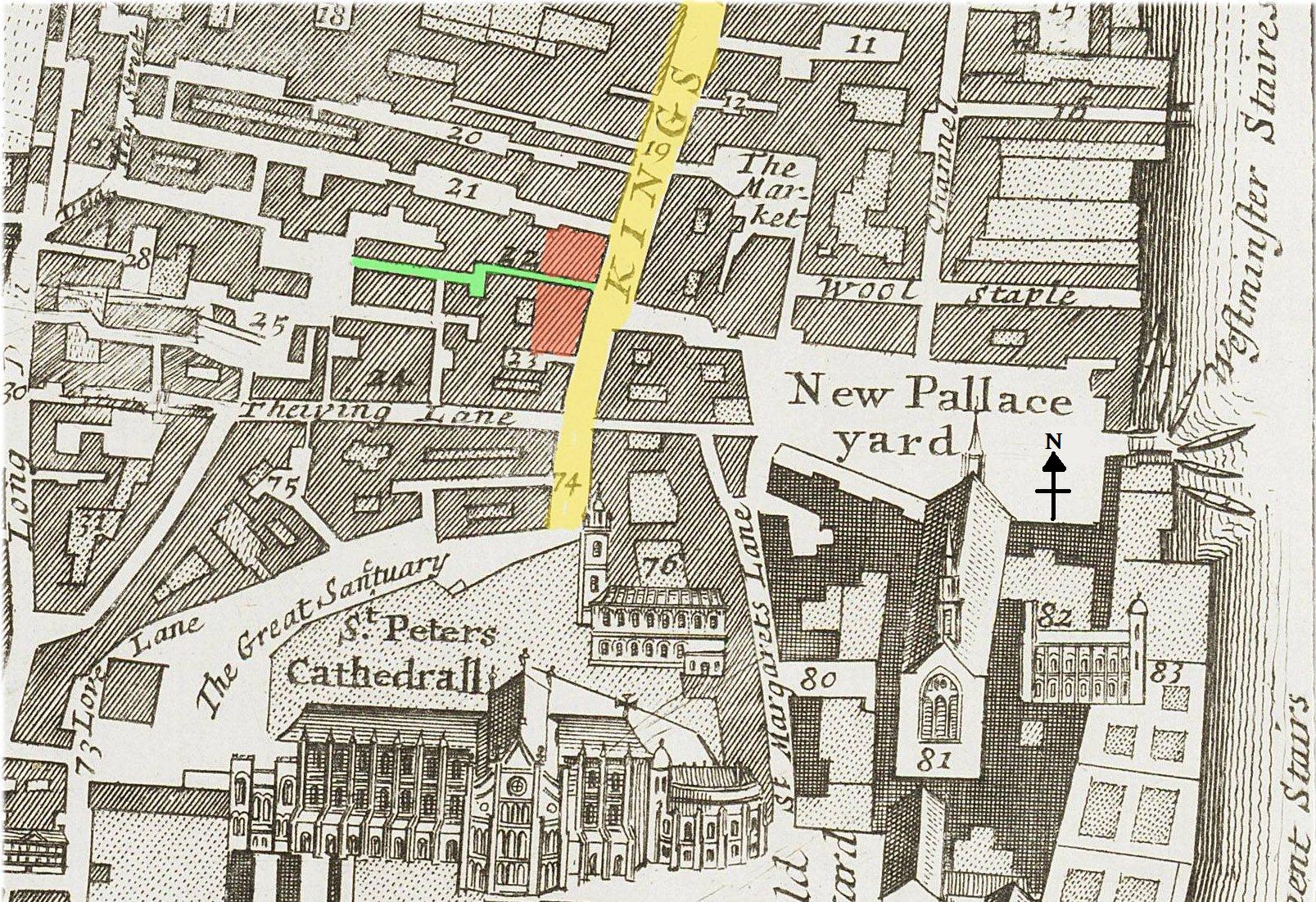
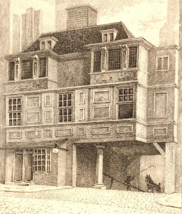
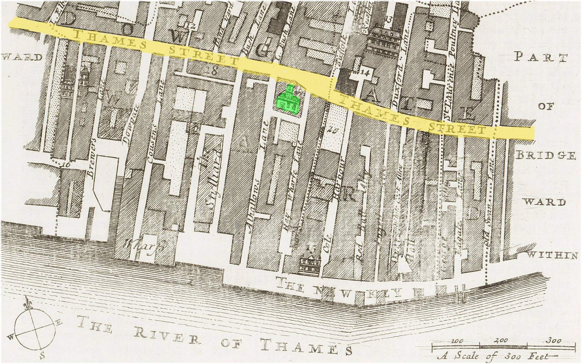
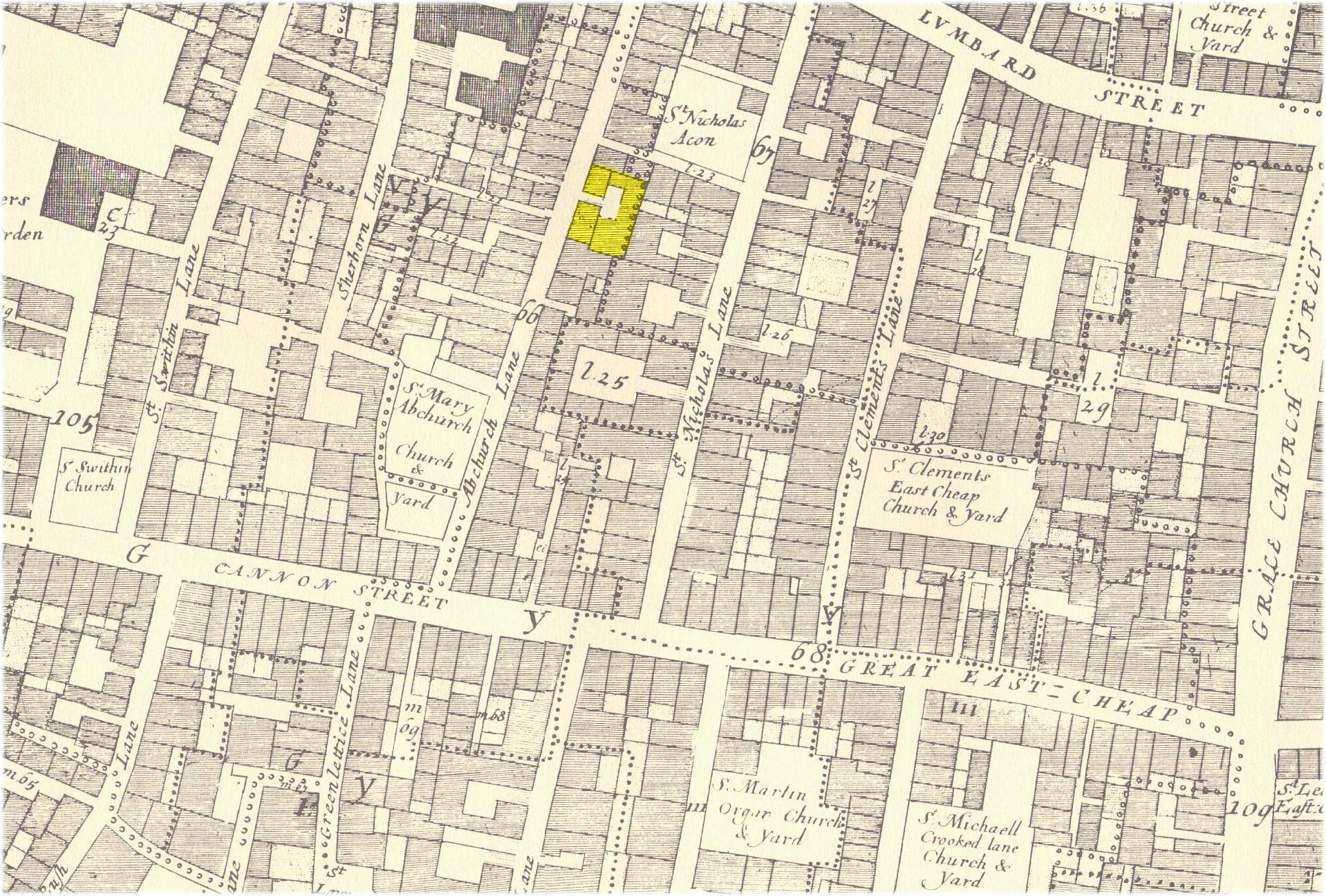
A review of the Hearth Tax returns for London on Lady Day 1666 indicates an entry for a John Kent in Lombard Street at a property containing 16 hearths (5). Such a number of hearths is in keeping with a well sized tavern of the period. The layout and geographical location sub-heading in of the Hearth Tax return document would indicate John Kent’s property was located at the east end of Lombard Street on the south side close to All Hallows parish church. Given that the contemporary accepted address for the three Tuns taverns as being in Gracechurch Street this coupled with the Hearth Tax return evidence would logically put the tavern’s location as being at the south-east corner of Lombard Street at the north-south junction with Gracechurch street. Presumably the tavern’s main entrance was via Gracechurch Street, hence it being known as the Three Tuns in Gracechurch Street. According to one source (6) citing John Roque’s 1746 map of London the Three Tuns tavern was located on the western side of Gracechurch Street, due east of the church of St. Clement’s Eastcheap but within the bounds of the parish of St. Benet’s. It is likely that this refers to the later tavern of the same name built in Gracechurch street after the Great Fire of 1666 (Note 2).
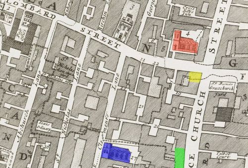
Gracechurch & Lombard Streets c.1720 indicating the locations of the pre Great Fire Three Tuns Tavern (YELLOW), post Great Fire Three Tuns Tavern (GREEN) plus All Hall0ws Church (RED) and St. Clement’s Eastcheap (BLUE)
Unfortunately there was to be more sorrow in the Kent household over the next three years as the following parish register entries from All Hallows, Lombard Street attest to;
Elizabeth Kent – Elizabeth Kent the wife of John Kent vintner in Gracechurch Street was buried in the South Chapel of our church on the south side underneath the first two pews upon the 28th day of December 1657
With two known surviving children still to look after and a family business to run the loss of Elizabeth must have hit John hard despite having some potential support from his apprentice(s) (Note 1). With this in mind it is not so surprising that within a year of Elizabeth’s death John was preparing to re-marry as recorded by the following banns entry in the parish register of All Hallows, Lombard Street made on the 29th October 1658;
A marriage intended between John Kent, widower of the Parish of All Hallows Lombard Street, and Elizabeth Barret, spinster, the daughter of Peter Barret, gentleman, of the Parish Margaret Pattens London, was published in the market place of Cheapside upon three market days, in three several weeks one after another, between the hours of eleven and five of the clock according to the late Act of Parliament that is to say upon Saturday the first, Monday the third and Wednesday ye 12th days of January 1658. & no exception was made against the same.
And on the 18th of January 1658 the said parties above named were married in Margaret Pattens Church by Mr. Thomas Lye minister of this parish.
Confirmation of John’s second marriage is also documented in the parish register of St. Margaret Pattens Church.
Exactly nine months after John and Elizabeth’s marriage the Kent family was to have yet more misfortune as recorded in the registers for All Hallows Church, Lombard Street.
Sarah Kent – Sarah the daughter of Mr. John Kent of the Three Tunns in Gracechurch Street was buried in the South Chapel of our church on the south side of the pews marked as 10, 11 upon the 18th day of September 1659
No baptism record has so far been found for Sarah Kent so it is not known if she was the product of John’s first or second marriage. Either is possible but the present writer is of the opinion that she was probably the infant daughter of John and Elizabeth Barret.
One further child was born to the couple while living in Gracechurch Street.
Dixy Kent – Dixy the son of John & Elizabeth Kent vintner at the Three Tuns in Gracechurch Street was baptised in the parish church the 26th day of January by Mr. Thomas Lye the minister
The Kent family appears to have survived the Great Plague of 1665. It is not known if they evacuated the city during the plague, as so many who could afford to do so did, but it must remain a distinct possibility. From details contained in John Kent’s Will of December 1689 (7) it is clear that at some point he acquired a considerable estate including a manor house (the Manor House of the Mark) straddling the parish boundaries of Walthamstow and Lower Leyton. This area was then a very rural part of Essex and a popular location with many of London’s leading citizens for the location of their second homes. If he had this estate in 1665 it may well have been to here or his family’s home village of Standon in Hertfordshire that he and his family escaped in order to survive the plague.
While the Kent family may have survived 1665 unscathed like most other Londoners there was to be a major upheaval in their lives in the following year.
The Great Fire of London broke out in Pudding Lane in the early hours of Sunday 2nd September 1666 and by the following evening it had consumed all of Gracechurch and Lombard Streets. The Three Tuns tavern was raised to the ground while the family’s parish church of All Hallows was severely damaged.
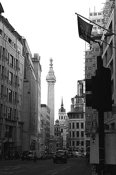
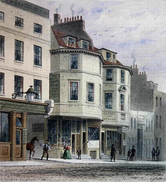
A view of the south end of Gracechurch Street with the Monument (marking the starting point of the Great Fire of London) clearly in full view.
At some time prior to the Great Fire of 1666 but after 1648/9 (i.e. the year in which the first London tradesman’s tokens were issued) John Kent issued the earlier illustrated farthing trade token from the Three Tuns tavern in Gracechurch Street. Unfortunately the fact that both his wives were called Elizabeth does not allow us to use the triad of initials on the reverse of the token to date it more precisely using contemporary parish marriage records. However, as previously mentioned, stylistically the token’s appearance suggests an issue date prior to c.1662.
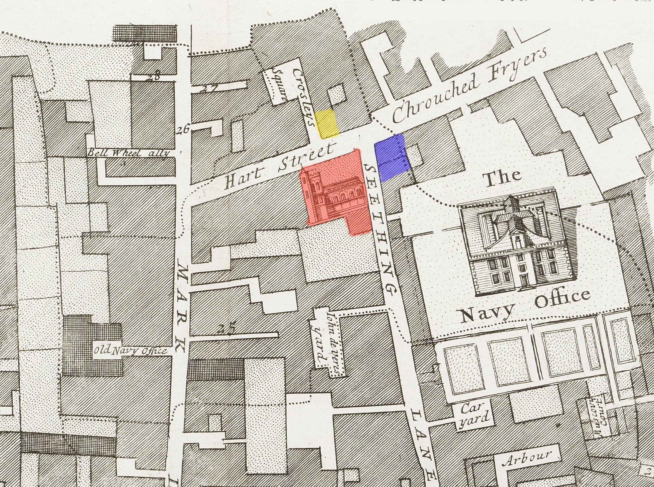
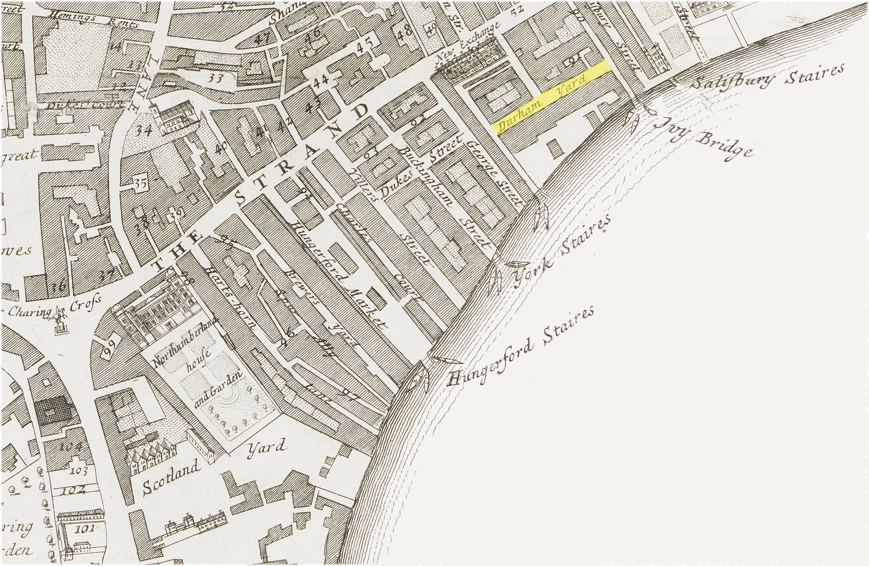
Despite losing their tavern and presumably home in Gracechurch Street in early September 1666, just over a month later John and Elizabeth Kent had re-established their business, under its former name of the Three Tuns, in a vacant property at the intersection of Hart Street and Crutched Friars in the parish of St. Olave’s, Hart Street (Note 3).
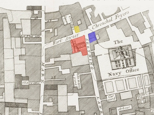
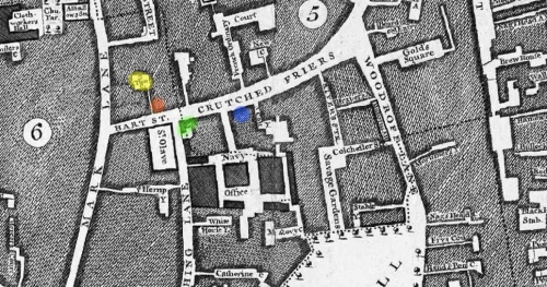
Seething Lane Area in 1678 – Showing the locations of Samuel Pepys’ Lodgings (BLUE); the parish church of St. Olave, Hart Street (RED) and that most likely for the Three Tuns Tavern (YELLOW)
This district, in the north-eastern part of the city, was one of the few areas which escaped the Great Fire. Properties in such areas would have been highly sought after and expensive after September 1666 as the Great Fire had laid waste to most of the city.
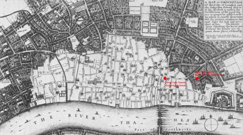
A map of London immediately after the Great Fire of September 1666 showing the extent of the devastation and the locations of the Three Tuns Taverns in Gracechurch Street and Crutched Friars
Crutched Friars is the eastern extension of Hart Street. Starting adjacent to the parish church of St. Olave this street ran alongside the north end of Seething Lane and the Navy Office where the famous diarist and naval administrator Samuel Pepys lived and worked respectively.
Shortly after moving into their new establishment John and Elizabeth Kent issued the undated farthing token illustrated and described earlier. In addition they also issued half penny trade tokens. As can be seen from the above images the design of this farthing token was very similar to the earlier one they issued when at the Three Tuns tavern in Gracechurch Street.
Samuel Pepys would have been a regular visitor to the Three Tuns tavern in Crutched Friars. Geographically speaking it was his “local pub”. Between November 1666 and May 1669 Pepys records in his diary visiting “the tavern in our street” on a total of seven different occasions. He frequented the tavern with friends and colleagues from the adjacent Navy Offices plus with his neighbours on the occasion of parish dinners which appear to have been regularly held there. On 17th November 1666 Pepys refers to the Three Tuns as “the new tavern come by us”. In May of the next year he further refers to the tavern as “Kent’s”. Two related and more interesting of his diary references to the tavern are reproduced below.
Thursday 9th May 1667 – ….and so home, and in our street, at the Three Tuns’ Tavern door, I find a great hubbub; and what was it but two brothers have fallen out, and one killed the other. And who should they be but the two Fieldings; one whereof, Bazill, was page to my Lady Sandwich; and he hath killed the other, himself being very drunk, and so is sent to Newgate. I to the office and did as much business as my eyes would let me, and so home to supper and to bed.
Friday 10th May 1667 – Up and to the office, where a meeting about the Victuallers’ accounts all the morning, and at noon all of us to Kent’s, at the Three Tuns’ Tavern, and there dined well at Mr. Gawden’s charge; and, there the constable of the parish did show us the picklocks and dice that were found in the dead man’s pocket, and but 18d. in money; and a table-book, wherein were entered the names of several places where he was to go; and among others Kent’s house, where he was to dine, and did dine yesterday: and after dinner went into the church, and there saw his corpse with the wound in his left breast; a sad spectacle, and a broad wound, which makes my hand now shake to write of it. His brother intending, it seems, to kill the coachman, who did not please him, this fellow stepped in, and took away his sword; who thereupon took out his knife, which was of the fashion, with a falchion blade, and a little cross at the hilt like a dagger; and with that stabbed him.
Documentary evidence suggests that John Kent lived the rest of his life as a practicing vintner in the parish of St. Olave, Hart Street and eventually even became a parish elder. However, it is unclear if he remained the resident landlord at the Three Tuns tavern in Crutched Friars after the late 1660s.
There is an additional series of interesting farthing and half penny trade tokens which were issued for the Three Tuns tavern in Crutched Friars in the names of Theophilus Pace and his wife. These are undated but in London the issue of half-penny trade tokens typically dates to the period 1664 to 1669 while farthings were issued over a longer period commencing in 1648/9. No trade tokens of any denomination were issued after their use was officially declared illegal in 1672. This highlights a question mark with regards to the exact dates of John Kent’s tenure at the Three Tuns tavern.
One possible explanation of the Theophilus Pace tokens is that the latter was let the Three Tuns tavern by John Kent sometime after 1667 and that he retained that position until his death. The parish registers for St. Olave’s, Hart Street records the burial of a “Theophilus Pais” in February 1667/68. Thereafter it is possible that John Kent took over the running of the tavern again possibly with the ultimate intention of passing it onto his son Dixy on his retirement.
Parish register entries from the later 1660s to early 1670s offer documentary evidence of a further five children (Mary, Elizabeth, Peter, John and a still-born child) belonging to John and Elizabeth Kent in addition to the seven (i.e. Mercy, Elizabeth, Sam, Francis, Sarah, John and Dixy) known to have been born while he lived in Gracechurch Street. At least three of these additional children were born while John and Elizabeth were based in Crutched Friars as is evident from the documentary evidence below. Firstly from the parish registers of Al Hallows, Lombard Street:
Mary Kent – Mary the daughter of John Kent and of Elizabeth his wife was buried in our church the last day of March 1667 towards the upper end of the south side close to the wall.
Peter Kent – Peter the son of John Kent and of his wife was buried in the south chapel 21 foot from the upper end from the head of the corpse at 2 foot from ye Side wall on the 5th of November 1667
Unbaptized – A small child of John Kent and of Elizabeth his wife. Still born was buried in our South Chapel on the 5th day of September 1670.
John Kent – John the son of John & Elizabeth Kent was buried in our South Chapel on the 13th day of August 1671 sixteen foot from ye end wall to the head of the corpse and about a foot from the side wall.
Secondly from the parish register of St. Olave, Hart Street:
John Kent – Baptism 6th September 1668 – John son of John and Elizabeth Kente.
John Kent – Burial 13th August 1671 – John son of John and Elizabeth Kente buried at All Hallows in ye church.
Elizabeth – Baptism 26th January 1672/3 – Elizabeth daughter of Mr. John Kente and Elizabeth Kente his wife born and baptised.
While the family became established in their new parish it is interesting to note that they continued to use their former parish church for family burials despite the fact that it had been badly damaged during the Great Fire of 1666. After the fire the local parishioners of All Hallows, Lombard Street attempted to “patch up” their church by rendering the walls with straw and lime in an attempt to stop any further decay (8). A bell was hung in the steeple, despite its perilous condition, as late as 1679 (9). Ultimately, however, restoration proved impractical and the old building was replaced with a new one designed by the office of Sir Christopher Wren and completed in 1694.
After the birth of Elizabeth in 1673 there are no further records of John and Elizabeth Kent having any further children. Of John Kent’s twelve children only five were to survive into adulthood (11).
In 1668 John Kent’s eldest daughter, Mercy, married John Sergent, an apothecary from the adjacent London parish of St. Katherine Cree (12) (Notes 4). Oddly their marriage didn’t take place in either the bride’s or the groom’s home parish. Instead the ceremony took place in St. Mary’s Church in Leyton, Essex. As previously noted, at some point in his history John Kent acquired a considerable holding of land in this area of Essex including the Manor House of the Mark on the parish boundary of Walthamstow and Lower Leyton. By the time of the marriage of John’s daughter in 1668 the association between his family and this area of Essex already appears to have been established. By 1680 John Sergent had died making Mercy a widow. It is possible that it was through her father’s connections and/or introduction she met her second husband, Philip Stubbs, who according to their marriage license was also a widower and vintner from a neighbouring London parish to St. Olave, Hart Street (13).
28th October 1680. “Phillipp Stubbs of St Andrew Undershaft Lond. Vintner aged about 44 years and a Widdower” and “Mrs Mercy Sarjeant of St Catherine Creechurch Lond. aged about 34 years and a Widdowe ” to be married in ye parish Church of Battersey in Surrey.
On 4th December 1677 John Kent apprenticed his youngest surviving son, Dixy, to Richard Acton, a London vintner. He probably hoped that Dixy would follow in his father’s footsteps (Note 5). It is unclear what trade Dixy’s older brother, John, entered as no record has so far been found for him in the transcribed apprenticeship records of the principal London Livery Companies.
Even when John Kent was in his mid-60s he was still very active in his chosen profession being appointed one of the Masters of the Worshipful Company of Vintners in 1681. It is likely that he took on his final apprentice in 1685 (Note 6).
By the end of 1689 John Kent’s health must have been failing. He prepared his last will and testament on 14th December 1689. He died and was buried eight days later. An entry in the parish register for St. Olave, Hart Street for the 22nd December 1689 records the following;
John Kent, vintner, was buried in All Hallows, Lombard Street, Lond.
While short and to the point this entry records some interesting facts about John in that;
- He remained a resident of the parish of St. Olave, Hart Street until his death.
- At the time of his death he remained an active vintner.
- The historic ties to his former parish of All Hallows, Lombard Street remained strong until the time of his death and he was buried in his family’s former parish church along with his first wife and his seven deceased children.
John Kent’s Will was proven the day after his burial (i.e. 23rd December 1689). It states that he was an Elder of the parish of St. Olave, Hart Street as well as confirming him being a citizen and vintner of the city of London and that he was to be buried in the parish church of All Hallows, Lombard Street;
“at the upper end of the first isle in the right hand under the window where the seat stood.”
John’s Will further confirms that he was survived by his second wife, Elizabeth, and five of his children, namely John, Elizabeth and Dixy Kent plus his married daughters Mercy (Stubbs) and Elizabeth (Upsher).
To his eldest son, John, plus his daughters Mercy Stubbs and Elizabeth Upsher John Kent left £5 each. Similar amounts were each left to his “worthy good friends” Doctor Josiah Clarke and Mr. John Newton. To his youngest daughter Elizabeth Kent he left £500 to be paid to her on her 21st birthday or day of marriage, which ever came first. After the payment of any debts the remaining of John Kent’s estate excluding eight acres of meadow land in Leyton Marsh near the Ferry House (which was in the tenure of Edward Dawson) was to be split equally between his wife, Elizabeth, and his youngest son, Dixy. This included the various meadow and pastures lands and tenements pertaining to the Manor House of the Mark, all of which straddled the parish boundaries of Walthamstow and Lower Leyton in the county of Essex.
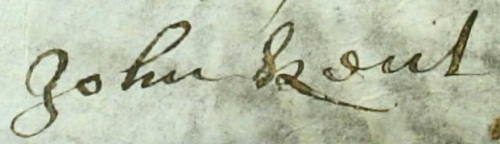
The signature of John Kent as it appears on the Apprenticeship Indenture of Throgmorton Underwood dated 4th February 1672/3.
Foot Notes:
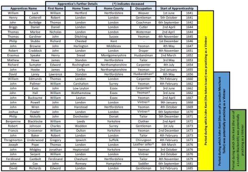
1) During the 51 year period that John Kent was an active vintner (i.e. from the completion of his apprenticeship in 1638 until his death in December 1689) the records of the Worshipful Company of Vintners record 34 separate apprentices who were bound to a master vintner by the name of John Kent. These are listed in the summary table below.
While it is possible that all of the above apprentices were bound to our token issuer, particularly considering his apparent long and successful career and the fact that not all apprentices completed their binding period, it is equally possible that those listed after 1655 and 1669 respectively could relate to the apprentices of one or other of two other John Kents who were bound apprentice vintners in London in 1648 and 1662 respectively. The apprenticeship records for these two additional John Kents are summarised below.
- John Kent, son of William a merchant tailor of London, apprenticed to Leonard Girle on the 1st August 1648. (1655)
- John Kent, son of John a blacksmith of London, apprenticed to Nicholas Clarke on the 6th May 1662. (1669)
While we can be certain that both of the above boys embarked on apprenticeships to become vintners we have no evidence that either of them either completed their standard seven or eight year apprenticeships or went on to become vintners in their own right. It was not unheard of that boys who successfully completed an apprenticeship in a one particular trade went on to become a master in a totally different but often related trade.
2) An interesting later reference to the second Three Tuns Tavern build in the lower portion of Gracechurch Street, after the Great Fire of 1666, can be found in the Daily Journal of 16th September 1732.
“Yesterday, about 5 o’clock in the evening, notwithstanding the wind was so high, a sailor flew from the top of the Monument to the Upper Three Tuns tavern in Gracechurch Street, which he did in less than half a minute; there was a numerous crowd of spectators to see him. He came down within 20 feet of the place where the rope was fixed, and then flung himself off; and offered, if the gentlemen would make him a handsome collection, he would go up and fly down again.”
3) George Berry (14) suggests that the location of the Three Tuns tavern in Crutch Friars was half way along Crutch Friars on the southern side of the lane opposite the Navy Office where Samuel Pepys worked. However, the current writer believes that the tavern’s location was on the west side of the entrance to Crown Court Alley (15) at the north-west end of Crutched Friars where the lane joined Hart Street.
Part of John Rocque’s Map of London (1746) indicating the location of the Three Tuns Tavern in Crutched Friards according to George Berry (BLUE) and the current writer (RED) plus the additional locations of Three Tuns Yard (YELLOW) and Samuel Pepys’ lodgings (GREEN).
This location better fits Samuel Pepys’ own words when he records in his diary the location of the Three Tuns tavern as being “in our street”. Further support of this theory comes from later place-name evidence contained in John Roque’s famous 1746 map of London. In this map Crown Court in Crutched Friars has been re-named as Three Tuns Yard. This presumably is in recognition of the location of a tavern by the same name. An advertisement in the London Evening Post of 3rd April 1742 reads;
“To be let – the house and shop lately occupied by John Calcott blacksmith in Crutch Friars. Enquiry at the Three Tun Tavern against the Church.”
The use of the term “against the church” further suggests the tavern was located opposite St. Olave’s Church on Crutched Friars as opposed to being located down the alley that lead to Three Tuns Court.
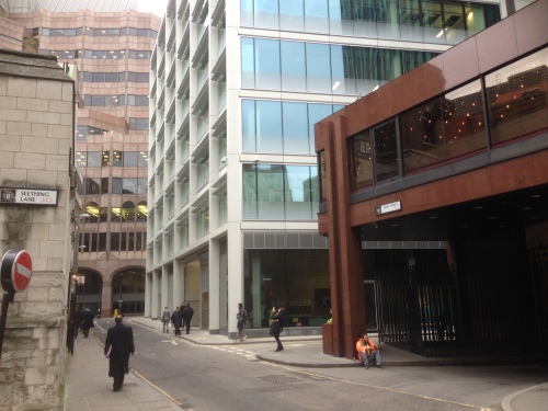
The junction of Seething Lane, Hart Street and Crutched Friars showing the entrance to New London Street (formerly the site of the Three Tuns Alley and Tavern).
Three Tuns Yard Alley was later to become New London Street, the original street entrance to which is still preserved (all be it as a dead-end turning) in the modern street plan of the north side of Hart Street.
4) It is possible that it was a close relation (i.e. a possible younger brother) of John Sergent’s the apothecary who married Mercy Kent in 1668 who was to be bound as an apprentice vintner to John Kent (the token issuer) in 1676 (see table in Note 1).
5) A Dixy Kent married Jane Brown on 11th January 1690 at All Hallows Church, London Wall. His trade is listed by Boyd as a linen draper and silversmith. If this entry is for Dixy Kent, son of John Kent, it indicates that he did not go on to follow in his father’s footsteps as a vintner despite being apprenticed as such. Dixy Kent died on 10th July 1696 and was buried in his father-in-law’s (Daniel Brown, died 1698) own vault in the parish church of St. Stephen, Wallbrook (16).
6) Further to Note 1 above it is interesting to note the areas of the United Kingdom from which the various apprentices came from. While many were from London or the Home Counties others were sent to London from as far afield as Mid-Wales and Yorkshire. It is highly likely that those apprentices listed as being from villages close to Standon in Hertfordshire plus Leyton and Walthamstow in Essex were bound to John Kent the token issuer given the close associations we know his family had to these two areas.
References:
- Webb, C. – London Livery Company Apprenticeship Registers. Volume 43. Vintners’ Company 1609-1800. (2006).
- Boyd, P. – Inhabitants of London. A genealogical Index held by the Society of Genealogists, London.
- Berry, G. – Tavern Tokens of Pepy’s London. (London, 1978).
- Latham, R.C. – The Diary of Samuel Pepys. Volume 10 – Companion. (London, 1995).
- Davies, M.; Ferguson, C.; Harding, V.; Parkinson, E. & Wareham, A. – London and Middlesex Hearth Tax. The British Record Society. Hearth Tax Series Volume IX, Part II. (London, 2014).
- Harben, H.A. – A Dictionary of London: Historical notes of streets and buildings in the City of London, including references to other relevant sources. (1918).
- PROB 11/397/409 – Will of John Kent (22nd December 1689), National Archives, London.
- Daniell, A.E. – London City Churches. (London, 1896).
- Godwin, G.; Britton, J. – All Hallows, Lombard Street. The Churches of London: A History and Description of the Ecclesiastical Edifices of the Metropolis. (London, 1839).
- Milbourn, T. – The Vintners’ Company: Their Nuniments, Plate and Eminent Members with
- Ibid 7.
- Ibid 2.
- Stubbs, H. – Pedigree of the Kentish Family of Stubbs. Archaeologia Cantiana. Volume 18. (1889).
- Ibid 3.
- Hyde, R. – The A to Z of Restoration London (The City of London, 1676). (London Topographical Society Publication. No.145. 1992).
- Ibid 2.