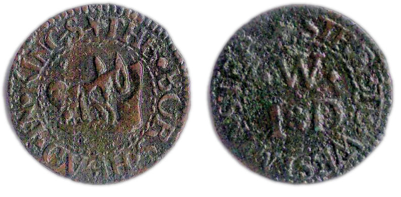
A farthing token of the Bell Tavern, King Street, Westminster
The above brass farthing token measures 15.9 mm and weighs 0.89 grams. It was issued in the name of The Bell Tavern which was once located in King Street in St. Margaret’s Parish, Westminster. The design of the token may be formally described as follows;
Obverse: (mullet) THE. BELL. TAVERN. IN, around twisted wire inner circle, depiction of a bell within.
Reverse: (mullet) KINGS. STREET. WESTMINS, around twisted wire inner circle, within a triad of initials comprising C | .D. | .M
While this particular token is undated on stylistic grounds its issue date can be attributed to the 1650s.
The triad of initials on the reverse of the token are those of its issuers, a Mr. “C.D.” and his wife Mrs. “M.D.”. As yet these individuals have not been identified but it is likely that Mr. C.D. kept the tavern at some period between 1641 and 1655. The later part of this period fits with the stylistic dating of the token. It is reported (1) that a William Austen kept the Bell in 1641 while between 1655 and 1664 the tavern was kept by the London vintner Samuel Walker and afterwards by his widow (2). A review of the 1664 Hearth Tax returns for King Street in Westminster confirms that Samuel Walker was paying tax on a property with 20 hearths in the southern end of the street.
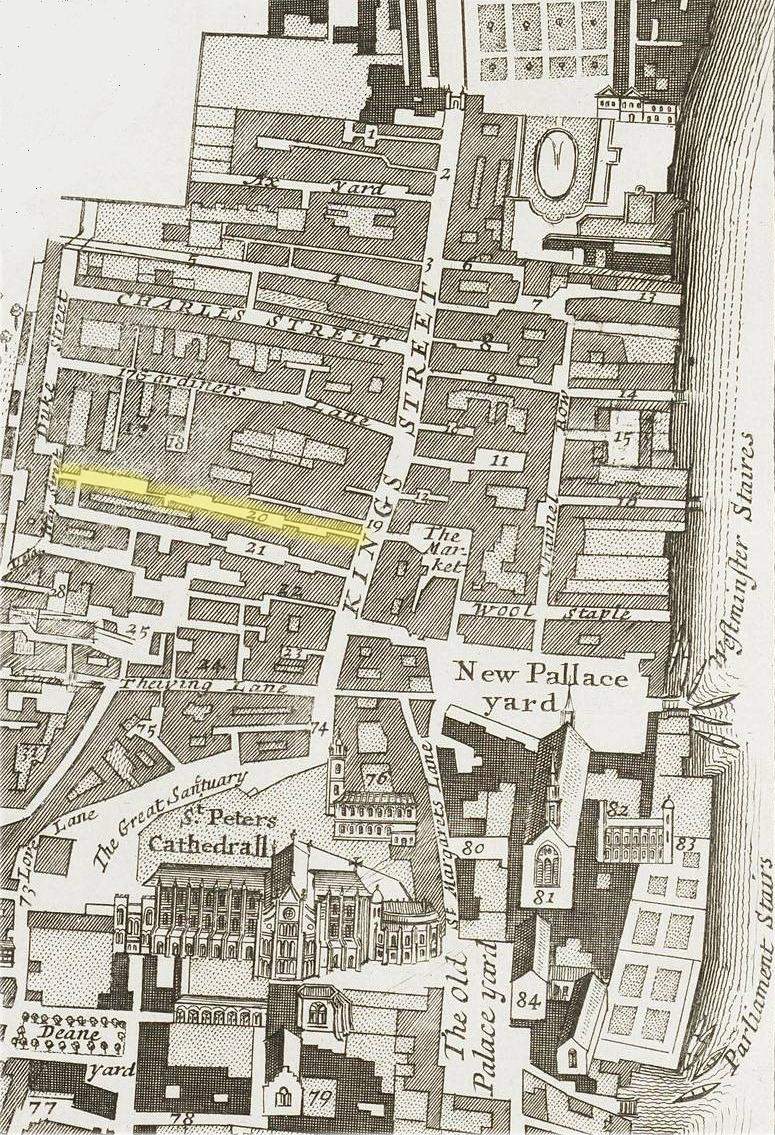
King Street was a narrow but very busy thoroughfare which once linked the southern side of Whitehall Palace with Westminster Abbey. Today its original course is largely marked by that of Parliament Street.

King Street, Westminster (c.1720) – From right to left – Downing Street (Red); Axe Yard (Blue); Bell Yard (Purple) & Bell Alley (Green).
At the north end of King Street, the corner of what is now Downing Street and what was then the southern side of Whitehall Palace, stood a gate called the King’s or Cock-pit Gate. It had four domed towers; on the south side were pilasters and an entablature enriched with the double rose, the portcullis, and the royal arms.

King’s Gate at the north end of King Street and southern entrance to Whitehall Palace. Demolished in 1723.
At the south end of King Street at the entrance to Palace Yard stood a second gate known as High Gate the construction of which commenced under King Richard II in 1384. These gates were demolished in 1723 and 1706 respectively (3).
There were innumerable courts, alleys and lanes leading off King Street. On the west, south of Downing Street, were Axe Yard, Charles Street, Gardiners Lane, Sea Alley, Bell Yard, George Yard, Blue Boar Court, Antelope Alley and Bell Alley. The street was the home for many of the principal taverns of Westminster which included the Blue Boar’s Head, the Swan, the George, the Angel, the Antelope, the Black Dog, the Old Rhenish Wine House, the Sun, the Trumpet and the Bell. Amongst the notable inhabitants of the area in the 17th century were;
- Oliver Cromwell and his mother who allegedly lived in a house close to the Blue Boar tavern.
- Erasmus Dryden, Member of Parliament for Banbury and grandfather of the famous poet John Dryden, lived in a house just north of the Sun tavern.
- Samuel Pepys, the famous diarist and Naval Administrator, who lived in Axe Yard off the north-west side of the street before moving to Seething Lane.
- Wenceslaus Hollar, the notable Bohemian artist and engraver, who died in poverty in a rented house off King Street in Gardiners Lane.
Although narrow, King Street was wide enough to accommodate all the pageantry of state coronations, funerals and other such pageants that passed through it. The street was reportedly picturesque (4);
“The houses rose up three and four stories high; gabled all, with projecting fronts, story above story, the timbers of the fronts painted and gilt, some of them with escutcheons hung in front, the richly blazoned arms brightening the narrow way.”
However it was reportedly also dirty (4);
“The roadway was rough and full of holes; a filthy stream ran down the middle, all kinds of refuse were lying about.”
King Charles I travelled down King Street on the way from Whitehall Palace to his trial at Westminster. He went back by the same route as a condemned man. In 1658 Oliver Cromwell’s funeral procession followed the same route. Cromwell himself narrowly escaped assassination in the street, where he had a house north of Boar’s Head Yard. While travelling along the narrow and crowded street in his state carriage he became separated from his guard. As the carriage passed a cobbler stall in the street Cromwell’s companion in the coach, Lord Broghill, saw a door in the premises open and shut, while something glittered behind it. Broghill immediately dismounted from the carriage and hammered at the cobbler’s door with his scabbard, when a tall man, armed with a sword, rushed out and made his escape into the crowd.
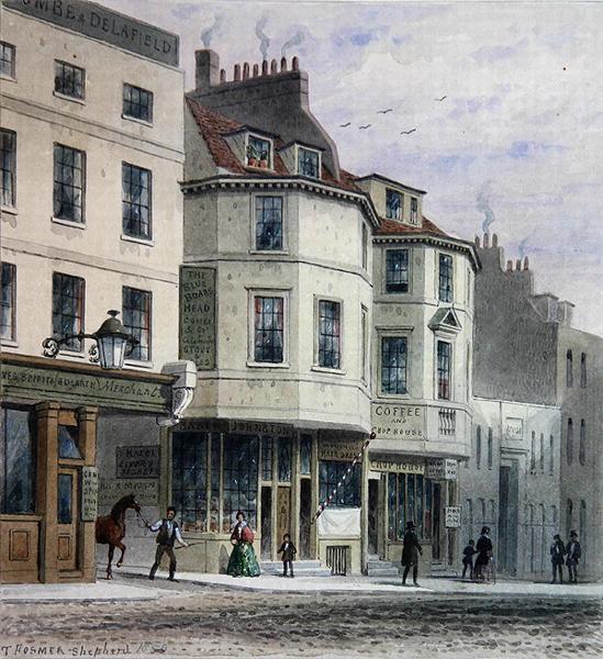
The Blue Boar’s Head in King Street – A mid 19th century view of the inn post its re-building in the mid 18th century.
Even in the mid-17th century the Bell tavern was regarded as an ancient establishment. The first known mention of the tavern occurs in 1465. Approximately 50 years later it is referred to as follows (5);
“A tenement called the Bell with a medowe and all the tenementes perteynyng to the same sett in the Kynges strete of Westminster.”
Not surprisingly the Bell Tavern was one of half a dozen taverns in King Street that was regularly visited and mentioned by Samuel Pepys’ in his diary. This particular tavern gets five mentions in the diary between March 1660 and February 1666/7 and was the location of one of his many extra marital liaisons on at least one occasion.
Shrove Tuesday 6th March 1660 – “So I went to the Bell, where were Mr. Eglin, Veezy, Vincent a butcher, one more, and Mr. Tanner, with whom I played upon a viall, and he a viallin, after dinner, and were very merry, with a special good dinner, a leg of veal and bacon, two capons and sausages and fritters, with abundance of wine. After that I went home…”
Monday 2nd July 1660 – “Met with purser Washington, with whom and a lady, a friend of his, I dined at the Bell Tavern in King Street, but the rogue had no more manners than to invite me and to let me pay my club.”
Saturday 9 January 1663/64 – “After dinner by coach I carried my wife and Jane to Westminster, leaving her at Mr. Hunt’s, and I to Westminster Hall, and there visited Mrs. Lane, and by appointment went out and met her at the Trumpet, Mrs. Hare’s, but the room being damp we went to the Bell tavern, and there I had her company, but could not do as I used to do (yet nothing but what was honest) …”
Friday 14 December 1666 – “So I to Westminster Hall, and there met my good friend Mr. Evelyn, and walked with him a good while, lamenting our condition for want of good council, and the King’s minding of his business and servants. I out to the Bell Taverne, and thither comes Doll to me…”
Friday 1 February 1666/67 – “Thence by water to Billingsgate; thence to the Old Swan, and there took boat, it being now night, to Westminster Hall, there to the Hall, and find Doll Lane, and ‘con elle’ I went to the Bell Taverne, and ‘ibi je’ did do what I would ‘con elle’ as well as I could, she ‘sedendo sobre’ thus far and making some little resistance. But all with much content, and ‘je tenai’ much pleasure ‘cum ista’. There parted, and I by coach home.”
Based on the place-name evidence apparent on the earlier illustrated plan of King Street (c.1720) at first glance there appear to be two possible locations for the Bell tavern. These being;
1) At the eastern entrance to Bell Yard at the northern end of King Street.
2) At the eastern entrance to Bell Alley at the southern end of King Street.
Thanks to the survival of a late 17th century hand bill advertising the sale of several paintings at in Westminster during mid-October 1691 the precise location of the Bell tavern becomes very apparent;
“At the Bell-Tavern over against the Gate-House in Kings-Street Westminster. Will be exposed to sale a curious collection of paintings; being most originals, by the best masters of Europe, on Tuesday, Wednesday, Thursday and Friday, the 13th 14th 15th and 16th of this instant October, 1691 Beginning exactly at four of the clock in the afternoon, and so will continue till all be sold.”
The hand bill clearly places the tavern at the head of Bell Alley at the southern end of King Street adjacent to “the Gate-House”. It is most probable that the gate house being referred to is that linking King Street with the western corner of New Palace Yard.
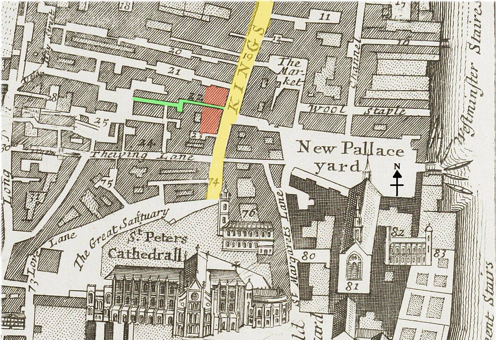
The southern end of King Street (c.1720) showing possible locations of the Bell tavern at the head of Bell Alley (marked in green).
This gate house can be clearly seen behind the ornamental fountain in the upper right hand side of a contemporary view of New Palace Yard as viewed from Westminster Stairs.

New Palace Yard 1647 by Wenceslaus Hollar – The Gate House in the north-west corner is that which is described as being adjacent to the Bell tavern in 1691.
During the reign of Queen Anne (1702 to 1714) the Bell tavern was the headquarters of the October Club, a boisterous fellowship of Tory parliamentarians who took their name from the strong winter ale they reportedly drank at their meetings.
In “A Journal to Stella”, Jonathan Swift makes an indirect reference to one of the October Club’s meetings at the Bell tavern (6);
10th February, 1710/11 – “We are plagued here with an October Club that is a set of above a hundred Parliament men of the country, who drink October beer at home and meet every evening at a tavern near Parliament, to consult affairs, and drive things on to extremes against the Whigs, to call the old ministry to account, and get off five or six heads.”
A few months later when Swift happened to be eating at the Bell tavern some prominent Octoberists invited him to join them at their dinner. But, he reported;
“I sent my excuses, adorned with about thirty compliments, and got off as fast as I could. It would have been a most improper thing for me to dine there, considering my friendship with the Ministry. The Club is about a hundred and fifty, and near eighty of them were then going to dinner at two long tables in a great ground-room.”
During the first quarter of the 18th century the Bell tavern was also the meeting place of a Freemason’s Lodge. By 1751 it appears that the tavern had been re-named as the Crown tavern (7).
References:
1) Berry, G. – Tavern Tokens of Pepy’s London. (London, 1978).
2) Latham, R.C. – The Diary of Samuel Pepys. Volume 10 – Companion. (London, 1995).
3) Brayley, E.W. & Britton, J. – The History of the Ancient Palace and late Houses of Parliament at Westminster. (London. 1836).
4) Besant, Sir W. & Mitton, G.E. – The Fascination of London: Westminster. (London 1902).
5) Cox, M.H. – Survey of London: Volume 10: St. Margaret, Westminster, part I: Queen Anne’s Gate Area. (London, 1926).
6) Rogers, P. – October Club (act. 1711–1714). Oxford Dictionary of National Biography. (Oxford University Press, 2013).
7) Whatley, S. – England’s Gazetteer: Or, An Accurate Description of All the Cities, Towns, and Villages of the Kingdom. Volume 2. (London 1751).