A mid-17th century token issued by a tradesman operating from the sign of The Three Tuns, near the Great Conduit in Cheapside, London.
The above copper farthing token measures 16.8 mm and weighs 1.17 grams. It was issued by a tradesman from the Cheapside Ward of London.
The design of the token may be formally described as follows;
Obverse: (mullet) AGAINST . THE . GREAT , around the depiction of three barrels in a triangular stacked arrangement.
Reverse: (mullet) COVNDVIT . IN . CHEAPSIDE , around a twisted wire inner circle. A triad of initials within reads, I|.H.|.S
The triad of initials on the reverse of the above token are those of its issuers. In this case a Mr. I/J.H (where “I” also represents “J” in the Latin alphabet) and a Mrs. S.H.
The design on the token’s reverse is almost certainly a depiction of the trade sign which hung over its issuer’s (or his neighbour’s) business premises. If it was his personal trade sign, and not just an historic one which had long been associated with the building he worked from, its design may well offer clues as to the token issuer’s trade.
The Three Tuns (i.e. barrels) was a fairly common trade sign in 17th century London and one typically associated with taverns. The sign is likely derived from the ancient coat of arms of the Vintners Company of London which, like the token, depicts three wine barrels.
The token’s issue date is not stated in its legend. However, on stylistic grounds it arguably dates from the 1650s or early 1660s. What is clear from the token’s design is the business address of its issuer, i.e. at the sign of the Three Tuns “against the Great Conduit in Cheapside”. This places the token’s issuing location in the heart of the parish of St. Mary Colechurch in the vicinity of the Mercers’ Hall, close to where Cheapside meets Poultry. This was the historic site of the Great Conduit, this being the name given to the flow dispensing house and tap system located at the terminus of London’s first public water supply system (Note 1). This “fresh” system operated from 1245 to the time of its partial destruction during the Great Fire of London of September 1666 (Note 2).
By 1666 there were no fewer than fifteen Conduits in London. They were generally sited in the middle of streets and typically comprised an elaborate pillar like stone structure, which supported an elevated lead tank, and had multiple outlet pipes from which water could be drawn via taps.
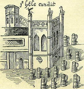
The depiction of the “Little Conduit” in West Cheapside from a print of 1585.
In Search of the Token Issuer
There are few clues as to the identity of the issuer of the above token. What we can be certain of is that his Christian name began with the letter “I” or “J” and that his surname began with the letter “H”. Furthermore, we know that at the time of the token’s production the issuer was married to a woman with a Christian name beginning with the letter “S” and that his business premises were “at the sign of The Three Tuns, against the Great Conduit in Cheapside”. Also, the style and value of the token infers that it was issued during the 1650s or early 1660s. The central image of three barrels on the token’s obverse additionally suggests that the issuer’s profession might have been that of a vintner and proprietor of a tavern in Cheapside having the trade sign (i.e. “The Three Tuns”).
The fact that our token issuer was a resident of Cheapside in the mid-17th century is fortunate as this Ward of the City has been heavily studied as part of the “People in Place Project” (1). This has led to a considerable amount of parish records and tax return information related to this area being transcribed and published in searchable data base format (2). Using these data bases, which cover the period 1610 to 1687, but which are not all encompassing in their content, searches have been made based on the following criteria;
- All males in the parish of St. Mary Colechurch with surnames beginning with “H”. Then, where sufficient information is available in the original records, searching within the resultant sub-group for those individuals with a Christian name beginning with either the initial “I” or “J”.
- All males in the parish of St. Mary Colechurch with surnames beginning with “H” who are recorded as being married. Then, where sufficient information is available in the original records, searching within the resultant sub-group for those individuals whose wives’ Christian names begin with the letter “S”.
A summary of the results from the above searches are listed in the table below.

Analysis table of mid-17th century male inhabitants identified from the parish records of St. Mary Colechurch who could have issued The Three Tuns trade farthing (click on image to enlarge).
From an analysis of the above presented data, coupled with the estimated dates between which the above token was issued, two possible issuer’s names stand out. These are John Higgenbottom and John Heath. Both men were married, as indicated by the Pew List for the parish church of St. Mary Colechurch.
The above data indicates that John Heath was resident in the parish of St. Mary Colechurch from at least 1649 until 1661 and that he was married from at least 1649 to 1658. Unfortunately his wife’s first name is not recorded in the parish church’s pew list and subsequent searches of local parish registers has failed to find any further evidence of her. John Heath is also listed as being one of fifty eight individuals whose property was destroyed in the Great Fire of September 1666. However, his name is not recorded as one of those who staked out his original building plot, in preparation for its rebuilding, after the fire (3).
As for John Higgenbottom, the above summary table indicates that he was first recorded in the parish in 1653 and was still present (or at least a person of the same name), in a re-built property after the Great Fire, until at least 1672. The parish pew list suggests he was married from 1656 to 1661. Again there is no evidence for his wife’s Christian name.
Further searches for the above two individuals have been made in the records of the Worshipful Company of Vintners, given the suggestion by the token’s design that this was the potential trade of its issuer. In the case of John Higgenbottom, no match has been found. However, in the case of John Heath multiple matches (Note 3) are available and furthermore two of these directly place a vintner of that name in the parish of St. Mary Colechurch in both 1654 (4) and 1662/3 (5).
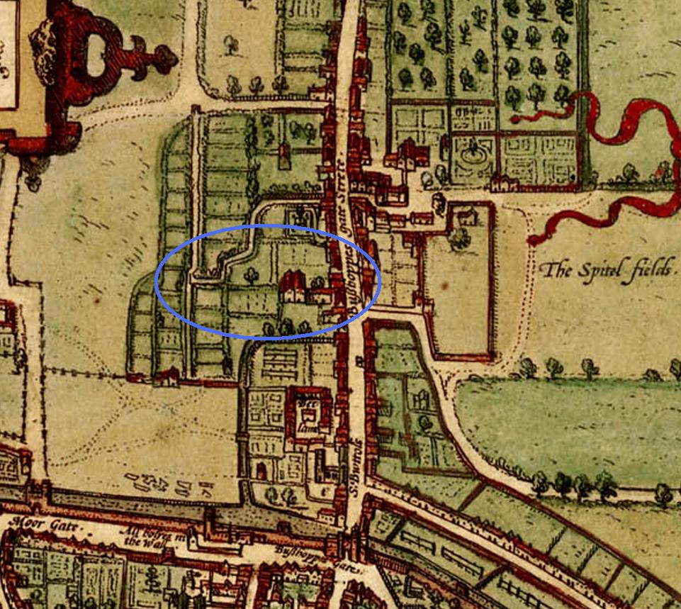
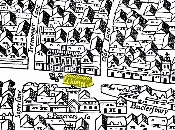
The Hearth Tax returns for 1662/3 lists a John Heath occupying a property containing 5 hearths in the parish of St. Mary Colechurch. Research conducted by the “People in Place Project” goes on to suggest that the property in question was one of the two indicated in yellow in the map of Cheapside parishes reproduced below (6). Both of these properties were located on the south side of Cheapside and were sandwiched between “Gropecunt Alley” on the west and “Bird in Hand Alley” on the east. Given the legend on John Heath’s token, i.e. “Against the Great Conduit in Cheapside”, it is most likely that of the two properties indicated below John Heath’s was that which faced onto the main street opposite the Great Conduit and Mercers’ Hall (i.e. that labelled number 2).

A reconstructed plan of part of Cheapside Ward, London as it would have been in the mid-17th century.
Despite being listed in the register of those who lost property in the parish of St. Mary Colechurch in the Great Fire of September 1666, John Heath is not listed in the parish as one of those who paid Hearth Tax on Lady Day of 1666. His place in the register for the properties of “Bird in Hand Alley” appears to have been taken by a Mr. William Empson (7).
This observation is puzzling but could be explained by a number of possible scenarios, including the following;
- Whilst still owning his property/tavern in Cheapside John Heath may have moved out of the parish, and possibly sub-let it to William Empson. Many of the wealthier classes moved out of London in 1665 to escape the ravages of the Great Plague. Not all of these people were to return to the city and many established new businesses outside of the capital whilst still retaining legal claims on their original London premises.
- John Heath may have been one of those thousands of unfortunate inhabitants of the city to have been claimed as a victim of the Great Plague which decimated London’s population in 1665/66. If John did die then, and was still married at that time, his widow and/or children (assuming he had any) would presumably still had claim to his property. Hence his name, as that of the lease holder of his Cheapside premises, could still have been recorded in the 1666 parish listing of those who lost property in the Great Fire.
A general search of mid-17th century London parish registers has so far failed to identify a Mr. John and Mrs. S. Heath. While the general parish records for St. Mary Colechurch contain multiple entries for John Heath and his un-named wife, their children (supposing they had any) are conspicuous by their absence in the parish’s registers of baptisms, marriages and burials. Only a single reference to the family has so far been found in this set of records and this is dated 20th September 1666 and is reproduced below;

The burial record of a “John Heath” from the parish registers of St. Mary Colechurch, London. Dated 20th September 1665.
We cannot be sure if the John Heath in this record is our token issuer or possibly a relation (e.g. his son) as neither the age or parents’ names of the diseased are given. It is tempting to think that the above register entry is a direct reference to the death of John Heath the token issuer. If this is the case it would explain why his name was absent from Cheapside Ward Hearth Tax retrurns of Lady Day 1666. Whilst no cause of death is recorded in the register its timing coincides with that period during which the Great Plague of that year was at its height. As such it is highly likely that the above entry was for a victim of the plague.
Footnotes:
1) In this case of the Great Conduit the word “Conduit” is used in an archaic sense. In medieval times it referred to the terminal point of a water supply system, whereas today the word would apply only to the pipeline. Today such a terminal structure would probably be termed a “Cistern” or “Public Fountain”.
2) The history of the Great Conduit started in 1237 with the purchase by the City Corporation of several fresh water springs to the west of the City Walls, near Tyburn. This was the beginning of a major civil engineering project to harness this water in a reservoir from where it could be channelled over 2.5 miles, via a gravity pipe line system, into the heart of the city. From here it could be tapped off for use by the public via a series of Conduits. Construction of this water distribution system, largely comprising buried lead pipes, took several years until by c.1245 the terminal structure, known as the Conduit, was completed. This pioneering initiative must have contributed greatly to the successful growth of the City in the years that followed. It was not until the 1390’s, when second and third Conduits, located further west in Cheapside, that the original one became known as “The Great Conduit”(8).

The course of the fresh water pipe line which served the Little and Great Conduits in Cheapside Ward, London.
By the 14th, 15th and 16th Centuries the original water supplies at Tyburn became further supplemented with natural fresh water supplies on high ground further west at Marylebone and Paddington and then from others to the north at Highgate, Highbury and Dalston (9). Some of these major extension works were financed by the City Authorities while others, such as the refurbishment of the Conduit Houses themselves, were undertaken by private citizens who donated large sums of money either during their lifetimes or by bequest in their Wills.
Families living locally to each Conduit had the right to tap water for their own domestic use free of charge. Typically they collected and transferred the water to their homes in large 6 gallon vessels, known as “tankards” or “tynes”, or alternatively pails, pots or half-tubs. Independent water-bearers also operated from the vicinity of the larger Conduits. These tradesmen effectively operated under a licence granted to them by the City Authorities to whom they had to pay an annual fee in return. They collected water from the Conduits in a variety of vessels for subsequent distribution around the city to both private homes and businesses (i.e. notably brew houses, tanneries and cloth dyers etc., etc.).

A mid-17th century London trade token likely issued by a fresh water delivery man operating from the Long Acre Conduit, London. His token clearly illustrates some of the tools of his trade for delivering water. On the obverse is a man with a yoke and two pales while on the reverse is depicted a horse drawn cart carrying a water barrel.
There are very few good contemporary images or descriptions of the Great Conduit in Cheapside. From what evidence is available it appears that in its final form it comprised a rectangular building, with a gabled roof, together with an adjoining tower, both having castellations. The latter possibly housed the Counduit’s lead cistern or head tank which supplied a series of gravity fed discharge taps below. These were possibly located on a common discharge manifold and were located the outer facing walls of the adjacent Conduit House.
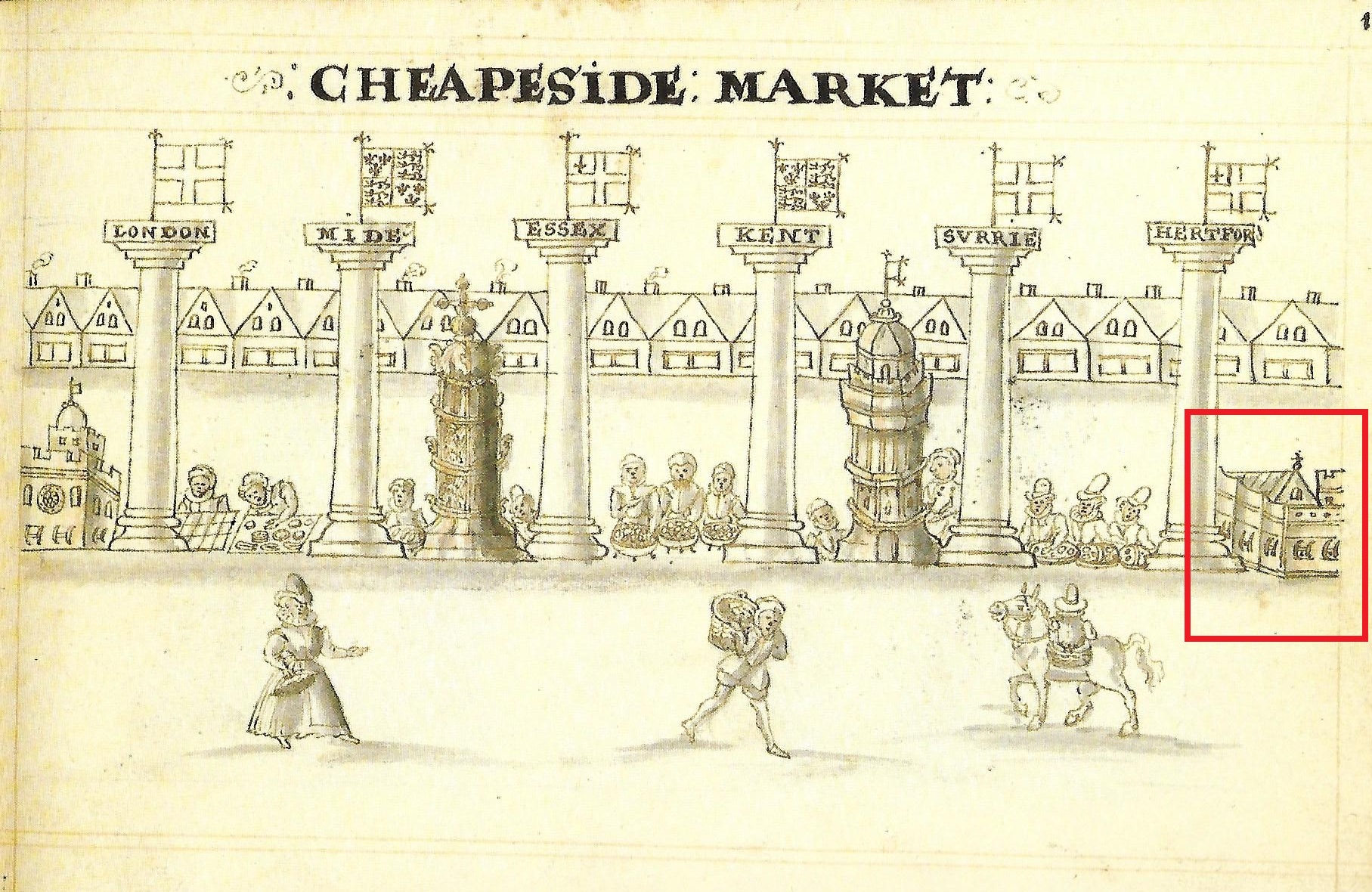
The depiction of Cheapside Market showing the “Great Conduit” (building far right). Taken from a page of Hugh Alley’s “A Caveat for the City of London” published in 1598.
The above described hydraulic arrangement of cistern manifold and taps is suggested in a representation of Cheapside Market contained in Hugh Alley’s “A Caveat for the City of London” published in 1598 plus in an earlier representation of the Conduit produced c.1550. The latter clearly shows the location of the Great Conduit in relation to the entrance to the Mercers Hall which was to its immediate north-west off Cheapside.

A section of a map of London (c.1550) showing the parish of St. Mary Colechurch and highlighting the location of the Great Conduit (in green) in front of the Mercers’ Hall.
A further representation of the Great Conduit, from the Agas Map of London, of c.1561, confirms its location at the junction of Cheapside and Poultry, just to the south of the parish church of St. Mary Colechurch but does not indicate the presence of the earlier noted adjoining tower structure. This omission may possibly be down to the map’s lack of precise detail and/or some degree of artistic licence in the Conduit’s representation. A lack of precise detail may also account for the omission of the same tower in the ground plan of the Great Conduit in Leake’s survey of London after the Great Fire, published in 1666. From this map the plan dimensions of the Conduit House may be roughly estimated as being 45 feet long (east to west) and 20 feet wide (north to south) (10). In both the c.1550 and 1561 representations of the Great Conduit groups of “tankards” or “tynes” can be clearly seen standing in the street immediately to the west.
A section of the Agas Map of London (c.1561) showing part of Cheapside Ward and highlighting the location of the Great Conduit (in yellow) in front of the Mercers’ Hall.
The Great Conduit was ruined by the Great Fire of 1666, and in 1669 was proclaimed as a “hindrance to the neighbourhood” and was removed by order of the City Authorities. The resultant reclaimed materials were sold with the exception of cistern which was taken to the Guildhall (11). By the time of the Great Fire the Great Conduit was arguably no longer in great use as by then many of the surrounding houses in the neighbourhood enjoyed their own piped running water, supplied from the New River.
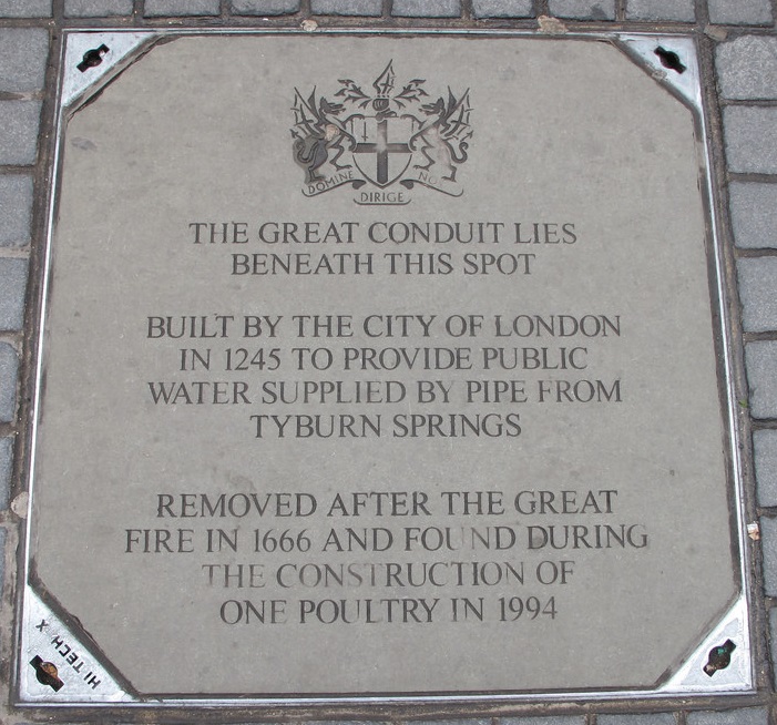
Manhole cover commemorating the history and location of the Great Conduit in Cheapside plus the present day entrance to its now buried undercroft chamber.
Today the approximate site of the Great Conduit is marked by both an official “Blue Plaque” and a further commemorative inscription on a manhole cover. This is no ordinary services manhole but one that leads directly to the remains of the Great Conduit original sub-structure or undercroft. This hidden chamber beneath Cheapside, was first discovered in 1899 during an inspection of local sewers (12). At that time it was wrongly identified as an ancient Roman Subway. Although reported at the time the discovery of this subterranean chamber was ultimately forgotten until in 1994 when it was re-discovered by British Telecom as part of the redevelopment of the site of No.1 Poultry.
At the time of its rediscovery in 1994 the Great Conduit’s undercroft had been largely backfilled with construction debris, presumably by workmen carrying out underground works nearby. The walls of the undercroft were found to be massive, measuring some 2 meters thick (13). This indicates that its original builders were fully aware of the significant loads the Conduit’s substructure would have to support from the large water filled lead cistern above.

The undercroft of the Great Conduit in Cheapside as it appeared when first discovered in 1899 and after its rediscovery and subsequent excavation by Museum of London Archaeology in 1994.
Both in the 1899 and the 1994 photographs of the undercroft can clearly be seen a doorway in its eastern wall (i.e. that facing onto Poultry). This indicates that at the time the Conduit was built in the 13th century the undercroft must have been at, or just below, the original medieval street level.
3) The records for the Worshipful Company of Vintners list two separate individuals by the name of John Heath who were apprenticed in London into the trade in 1624/5 and 1634 respectively (14). Their respective entries in the company’s apprentice register are summarised below.
- John Heath – Son of John Heath of Bermondsey, Surrey apprenticed to Thomas Angell on 2nd March 1624/5.
- John Heath – Son of John Heath, a gentleman of Bristol, Gloucestershire, apprenticed to Ralph Moore on 4th November 1634.
In the 17th century the duration of most apprenticeships, served for a master of one of the London Livery Companies, was typically seven years. Boys were typically bound into such apprenticeships between the ages of 12 and 14 and would have come to the capital from all over Britain.
Records also exist in the Vintner’s Company of a John Heath, presumably referring to one or both of the above individuals, acting as master and taking on his/their own apprentices as listed below;
- George Geary, apprenticed on 3rd November 1648.
- William Eames, apprenticed on 4th November 1651.
- John Moore, apprenticed on 7th September 1658.
As yet no evidence has been found linking any of the above apprentices to the parish of St. Mary Colechurch and as such the token issuer John Heath.
References:
- People in Place – Families, households and housing in London 1550-1720. (history.ac.uk/cmh/pip).
- Merry, M & Baker, P. – Source specific data sets, Cheapside and Tower Hill, 1558-1769. On-line data sets accessible at http://sas-space.sas.ac.uk/id/eprint/752 . (Institute of Historical Research, Centre for Metropolitan History, London, 2007).
- Mills, P. & Oliver, J. – The Survey of Building Sites in the City of London after the Great Fire of 1666. (London Topographical Society Publication. No.103. 1967).
- Rogers, K. – The Mermaid and Mitre Taverns in Old London. Entry for the Mitre Tavern, Cheapside. (London, 1828).
- Keene, D.J. and Harding, V. – Historical Gazetteer of London Before the Great Fire Cheapside; Parishes of All Hallows Honey Lane, St Martin Pomary, St Mary Le Bow, St Mary Colechurch and St Pancras Soper Lane. (London, 1987).
- Ibid 5.
- Ibid 6.
- Flaxman, T. – The Great Conduit in Chepe. (Worshipful Company of Water Conservators. London, 2014).
- Ibid 8.
- Ibid 5.
- Ibid 5.
- Wintle, W.G. – London Underground: a visit to the subterranean city. (Harmsworth Magazine, Volume 3, September 1899.).
- Burch, M; Treveil, P. & Keene D. – The development of early medieval and later Poultry and
- Cheapside: Excavations at 1, Poultry and vicinity, City of London. (Museum of London Archaeology, Monograph 38, 2011).
- Webb, C. – London Livery Company Apprenticeship Registers. Volume 43. Vintners’ Company 1609-1800. (Society of Genealogists, London. 2006).